Visit the Mighty 5!!!
Southern Utah’s Mighty 5 national parks are a must for the bucket list. Canyonlands, Arches, Capitol Reef, Bryce Canyon and Zion National Parks will leave you with a lifetime of memories.
Explore Utah’s 5 national parks, AKA The Mighty 5, with this 10 day, self-drive itinerary compiled by visitutah.com.
Day 1: Salt Lake City to Arches National Park
Distance: 231 miles/3.5 to 4 hours
Start in one of Utah’s most vibrant cities, then head out on an expedition to Arches National Park, where 300 million years of patient erosion has resulted in unbelievably dramatic landscapes that look more sculpted by giant mythological beings than the processes of time.
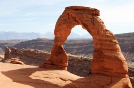
Arches National Park contains about 2,000 windowed arches, towering spires, harrowing hoodoos, and precarious pinnacles on display, including Delicate Arch, perhaps Utah’s most iconic feature, which is a must-hike destination in the park. A paved 40-mile scenic drive from the park entrance provides numerous parking areas for trail access and scenic overlooks.
Guided Tour: Reserve a tour through the Fiery Furnace. This twisting labyrinth of brilliant red rock fissures and spines is so intricate it is highly recommended to find your way through with a guide.
Hikes: The 1.5-mile hike to Delicate Arch is beautiful, with the end reward of viewing Utah’s famous landmark, a famed standing any bucket list. Or hike some of the easy short trails in the park, such as the Park Avenue Trail and trails in the Windows Section of the park, or some of the longer trails in the park, such as Double O Arch, Tower Arch, and Landscape Arch.
Drive: The 36-mile round trip Arches scenic drive can take about 2.5 hours. Be sure to visit the Windows Section, which contains some of the area’s largest arches.
Additional park activities: backpacking, biking, camping, canyoneering, ranger-led programs, and rock climbing. While the trailheads for most of Arches National Park’s best hikes are accessible by car (which also means it’s important to plan ahead during peak season), Arches also has some backcountry open for exploration. Depending on what time you arrive, where you’re planning to stay for the night and your skill in the backcountry, this might be option worth your consideration.
Get There:
Destination: Moab. This world-class destination is under four hours away. The visitor center is located five miles north of Moab via U.S. Highway191.
DAY 2: Arches National Park to Canyonlands National Park
Distance: Moab to Canyonlands National Park, Island in the Sky district is 35 miles/approximately 46 minutes. Distance: Moab to Canyonlands National Park, The Needles district is 75 miles.
Imagine wave after wave of deep canyons, formed by the currents and tributaries of Utah’s Green and Colorado rivers, divided with towering mesas, pinnacles, cliffs and spires, and spread out over tens of thousands of acres of some of the world’s most breathtaking red rock country. Now multiply that vision by three. Canyonlands National Park is made up of three distinct land districts, each increasingly more remote, more startling and more alluring to any traveler.
Photography: Early morning and late afternoon bring the best photographic light to the park during the “magic hours.” The park website recommends photo-worthy areas and formations, as well as peak times for photography opportunities.
Must See: Travel Dead Horse Mesa Scenic Byway to Dead Horse Point State Park for a dizzying view some 2,000 feet above the Colorado River as it winds its way into Canyonlands National Park. You’re sure to treasure this panoramic perspective of the river that carved out the canyons. This is a locals’ favorite and definitely something you should add to your itinerary.
Canyonlands National Park is Utah’s largest national park with views thousands of feet down to the Green and Colorado Rivers and thousands of feet up to red rock pinnacles, cliffs, and spires. Rivers have sliced the parks into three districts: Island in the Sky is the northern section where visitors can look down to the Colorado River on the east and the Green River on the west; The Needles District is named for its profusion of red rock spires and sandstone fins; and the Maze District is a remote and jumbled stone playground and requires backcountry use permits year-round.
Walk: Mesa Arch is a relatively easy 30-minute jaunt that leads to an arch perched right on the edge of towering sandstone cliffs and is especially beautiful at sunrise.
Hikes: Island in the Sky, the park’s most accessible and visited district of the park, allows for a bird’s eye view of this vast and awesome landscape. The “Island” sits atop a mesa over 1,000 feet above the surrounding terrain, the source of its aptly given name. The Grand View Point Trail is a mild two-mile round trip hike to the southernmost edge of the “Island” with expansive views of the complex canyon system formed by the convergence of the Colorado and Green Rivers. This is a must-see!
Drives: A few hours: Drive the park’s 20 miles of paved roads and enjoy the spectacular views. Sunrise and sunset are particularly beautiful times of day to enjoy these lofty panoramic views of canyon country. You can drive all the way down to the Colorado River via Lathrop Canyon.
Backpacking: Backpackers can experience the solitude of the park by hiking trails of White Rim (steep & strenuous) and spend the night in the backcountry. Reservations for White Rim campsites and backcountry permits are required.
Additional park activities: drives, backpacking, camping, climbing, horseback riding, and ranger-led programs.
Getting There:
Major entrances to the park are accessible from U.S. 191. Access to Island in the Sky is 35 miles northwest of Moab and access to the Needles District is 22 miles north of Monticello or 1.5 hours south of Moab.
DAY 3: Upper Colorado River Scenic Byway and La Sal Mountain Loop Road
A real pleasure of any Mighty 5® itinerary is traveling the roads between them. A solid hike up Negro Bill Canyon will give your legs a good stretch before finishing the day with a scenic loop drive to wind down for tomorrow’s big adventure. For even bigger adventure, consider a two-day rafting trip instead of today’s scenic drives.
Bike: Start your morning with a ride in Canyonlands National Park. The biking terrain in the park is famous and offers a variety in difficulty and scenery. The White Rim in Island in the Sky is a 100-mile trail that you can start at any point. If you are interested in more difficult roads, try The Maze area. Please check conditions before heading out on trails.
Drive The Upper Colorado River Scenic Byway, Utah state Route 128 (S.R. 128), follows the Colorado River corridor as you travel through a beautiful desert canyon which illustrates the convergence of landscapes that makes the Southern Utah area so unique. Towering sandstone cliffs and desert mesas combine with the mighty waters of the Colorado River and the oft-snow capped peaks of the La Sal Mountains.
Hike: Negro Bill Canyon is found along S.R. 128, three miles east of its junction with U.S. 191. This four-mile round trip hike takes you through a scenic canyon with a perennial stream leading to Morning Glory Natural Bridge. At 243 feet long, it’s the sixth longest natural rock span in the United States. The average person can complete the hike in about four hours.
Drive La Sal Mountain Loop Road, a paved scenic backway leading to views of forested mountains and alpine lakes, plentiful wildlife, including deer and elk, and expansive views of the red rock desert below. Along the route are numerous hiking and biking trails. The entire loop is approximately 60 miles and takes about three hours to complete. To access the La Sal Mountain Loop Road, drive east on S.R. 128 approximately 15 miles from its junction with U.S. 191 and turn right on Castle Valley Road. Continue on Castle Valley Road for approximately 11 miles to the La Sal Mountain Loop Road and turn right.
DAY 4: River Rafting/Jet Boating the Colorado River and Hummer Ride at Sand Flats Recreation Area
This is the day you’ve been preparing yourself for: plan with area guides the river trip that’s perfect for you. Time permitting, an off-road tour of some killer BLM land in the heart of the Colorado Plateau will help you dry off.
Float: Your Moab experience just wouldn’t be complete without a Colorado River activity. Whether it’s mild white water, an exhilarating class IV or V run through Westwater or Cataract Canyon, or a jet boat trip beneath soaring sandstone cliffs, there are several Moab guides and outfitters that offer the river trip of your choice.
Off-Road: Take an off-road tour with an experienced guide at the Sand Flats Recreation Area. Enjoy the legendary slickrock from the vantage point of an all-terrain vehicle in this off-road enthusiast’s paradise.
DAY 5: Moab to Monument Valley
Distance: Moab to Newspaper Rock — 53 miles/approximately 1 hour
Distance: Newspaper Rock to Monument Valley — 121 miles/2 hours 42 minutes
Drop south from Moab on S.R. 191/U.S. 163 and experience the vast geography of the southeast corner of Utah.
Monument Valley, an iconic symbol of the American West, is the sacred heart of the Navajo Nation. In some ways, Monument Valley Navajo Tribal Park is the definitive West. The rugged, disruptive landscapes are infused with ancestral spirits yet are hauntingly familiar thanks to Hollywood’s long love affair with this land.
Visit: Newspaper Rock National Historic Site — Wonder at the connection you’ll find at one of Utah’s large petroglyph panels to North America’s prehistoric human past. The Dinosaur Museum in Blanding contains stunning dinosaur exhibits, movies, slide shows and more. Bluff Fort Historic Site in Bluff preserves and displays the legacy of the settlers who blazed the remote and rugged Hole-in-the-Rock Trail and, ultimately, founded Bluff.
Drive: Monument Valley was made famous in the classic John Ford westerns, including Stagecoach and The Searchers, and inspires awe with its dramatic, arid landscape, and nostalgia with its connection to classic American cinema.
History and Culture: On arriving in Monument Valley, consider stopping by the Goulding Film and Cultural History museum at Goulding’s Lodge located in Oljato, Monument Valley. It’s the perfect introduction and educational resource for what you’ll see in the valley and also has lodging available.
Guided Tour: Monument Valley Tribal Park has stunning vistas of the Navajo Nation lands in the most photographed region. Guided jeep tours and hikes will get you up close and personal with Monument Valley’s incredible landforms, which are unlike anything in the world.
Options along the way:
State Parks: Edge of the Cedars State Park in Blanding contains an Anasazi village inhabited between AD 825 to 1125, with fragile and amazing artifacts featured on display, Goosenecks State Park offers spectacular views of an “entrenched meander” where the San Juan River carved 1,000-feet deep twists. Few other vacations can offer glimpses of such unbelievable geology!
DAY 6: Natural Bridges National Monument to Goblin Valley State Park
Distance: Monument Valley to Natural Bridges National Monument — 107 miles/approximately 2 hours 19 minutes (S.R. 261 to westbound S.R. 95 and S.R. 275)
Distance: Natural Bridges National Monument to Goblin Valley State Park — 126 miles/approximately 2 hours 30 minutes (S.R. 95 to northbound S.R. 24)
If you’ve stayed in Monument Valley, set an alarm to wake up before dawn and get on the road early. The view will be worth it. The stillness of the desert in the early morning is magical. The long shadows of early light bring out the sinuous curves of a landscape sculpted over tens of thousands of years by forces largely invisible to us as we pass through.
Visit: Natural Bridges National Monument was Utah’s first national monument and is home to three spectacular bridges sculpted by flowing water. “Sipapu,” the largest of the three bridges is, by some measurements, the second largest natural bridge in the world. Depart for Natural Bridges National Monument.
State Park: Goblin Valley State Park contains thousands of hoodoo-like rock formations or “goblins.” A must-see.
Getting There:
Trail of the Ancients National Scenic Byway — Highway 95 crosses the Colorado River, the northeastern reaches of Lake Powell, and the Dirty Devil River, and meanders the archaeological heartland of America, traversing the striking, classic Utah canyon country.
DAY 7: Capitol Reef National Park
It is no wonder the Navajo called this the Land of the Sleeping Rainbow. The contrast of red Entrada and white Navajo sandstones and the magnificent warp in the crust of the earth create surreal landscapes unlike any you have seen.
Capitol Reef National Park splashes color for 100 miles through an inviting wilderness of sandstone formations, rock art petroglyphs telling the story of the early indigenous people of the Fremont Culture, and large fruit orchards of Fruita, an early pioneer settlement. The central geologic feature, the Waterpocket Fold, is a bulging uplift of rainbow-hued sandstone “reefs” and canyons. Several easy hiking trails and a 25-mile scenic drive are found in this area. The park is 11 miles east of Torrey or 37 miles west of Hanksville on S.R. 24.
Drive: The scenic road from Grand Wash to Capitol Gorge winds through the park’s natural wonderland, where mysterious petroglyphs tease the imagination and dramatic slot canyons lure intrepid explorers with pristine natural beauty and solitude.
Visit: The old Fruita Schoolhouse and Historic Gifford Homestead dwellings provide a glimpse of 19th-century Utah pioneer farm life, located along Highway 24.
Walk: Take a stroll among the historic fruit orchards in the Historic Fruita District in the park and take some home with you, when in season.
Hikes: The park rangers can inform you on the easy hike to Hickman Bridge to the longer hike to Cohab Canyon. These hikes give an up-close look at the desert region with a natural bridge spanning the landscape.
Additional park activities: astronomy programs, backpacking, bicycling, family-oriented park-educational games, fishing, picnicking, and ranger-guided walks.
DAY 8: Scenic Byway 12-All American Road
Ready for a drive you’ll never forget? Utah’s All-American Road, a top national designation, awaits. Scenic Byway 12, is a spectacular experience by itself, and this 10-day itinerary give you breathing room to slow down and experience all it has to offer.
Distance: Torrey to Bryce Canyon National Park — 116 miles
Drive: Climb Boulder Mountain through the Dixie National Forest, then wind through Grand Staircase-Escalante National Monument linked by this outstanding Scenic Byway 12-All-American Road. During your drive along Scenic Byway 12, you will find that the journey here truly is the destination.
Hike: Stroll Lower Calf Creek Falls between Navajo sandstone cliffs vividly decorated with nature’s creative hand, which has left mineral streaks called “desert varnish,” enroute to an idyllic waterfall. This 5.5-mile round trip hike takes approximately three hours to complete.
State Parks: Anasazi State Park Museum features displays of an ancient Ancestral Puebloan community. Escalante Petrified Forest State Park — Hike along hillside trails, canoe or kayak on Wide Hollow Reservoir, and view fossils and petrified wood at the visitor center. Kodachrome Basin State Park — Sixty-seven monolithic stone spires called sedimentary pipes accentuate multi-hued sandstone layers revealing 180 million years of geologic time.
Optional Backcountry Tour:
The Burr Trail is a scenic drive, accessing some of Utah’s most spectacular canyon country. The first stretch of the road begins at Boulder for 18 miles through the Grand Staircase-Escalante National Monument to the border of Capitol Reef National Park. The remaining 50 miles is a graded dirt road that is usually passable by a passenger vehicle.
DAY 9: Bryce Canyon National Park
We call it Hoodoo Country. It sounds like “voodoo” for reasons you’ll have to see to believe. It all translates into a newfound respect for Mother Nature. Bryce Canyon’s view from 9,000 feet (2,743 meters) is unlike anywhere else in the world.
Bryce Canyon National Park is a series of natural amphitheaters sunk into pink cliffs and filled with delicate red rock “hoodoos.” The most brilliant hues of the park come alive with the rising and setting of the sun. Summertime offers a myriad of walking/hiking trails and a 37-mile scenic drive overlooking incredible vistas. Bryce Canyon Lodge, a National Historic Landmark, is open April through November.
Drive: You’ll want to drive the 38-mile Scenic Loop in the hours around sunrise or sunset and the park’s otherworldly formations and brilliant colors come alive.
Hike: The Navajo Loop Trail is an easy 1.3-mile hiking path, wandering through rock formations, drawing you into the mystical hoodoos’ perspective.
Ride: Book a guided mule or horse trip in the morning to the floor of the park, passing a stunning series of rock formations along the way.
Ranger Program: Park rangers will share interesting facts and activities about the park, including wildlife stories, geologic history, kids interests, full moon hikes, astronomy, and snowshoeing.
Additional park activities: camping, mule rides, horseback rides, ranger & astronomy programs. There is also plenty of backcountry to explore.
DAY 10: Bryce Canyon National Park to Zion National Park
Distance: 86 miles/approximately 1 hour 55 minutes
Zion National Park’s soaring towers and massive monoliths offer a spectacular grandeur. Over 100 years old, it is also Utah’s most popular park, welcoming nearly 2.6 million visitors in 2010. There are numerous easy, self-guided trails and more adventurous or strenuous hikes found in the park. Two entrances to Zion are 33 miles east of I-15 or 12 miles west of U.S. 89, both on S.R. 9. The northern Kolob Canyons section is accessible off I-15, 18 miles south of Cedar City.
Zion translates to “The Promised Land,” and that means for you some of the most spectacular hiking of your lifetime and impossible landscapes you will never forget. Carved by water and time beyond the stretch of the imagination, Zion National Park is a canyon that invites you to participate in the very forces that created it.
Drive: A multi-passenger shuttle system is the only motorized transportation allowed in the main canyon during the peak summer season, and includes a “town loop” that stops in the town of Springdale at the park’s south entrance. Visitors can use private vehicles to tour the park on S.R. 9, but over-sized vehicles are subject to restrictions and a fee charged for escort through a mountain tunnel.
Hike: The Emerald Pools in the park is a relatively easy three-mile, round-trip, signature hike and is fun for the whole family. Or choose a more strenuous adventure in The Narrows or The Subway (permit needed for the latter). You certainly won’t want to miss Angels Landing, a classic park hike that should not be taken lightly. It rises nearly 1,500 feet from the canyon floor to its final viewpoint. Many people consider the views here to be some of the most spectacular in the world. Only those who are physically fit and not afraid of heights should attempt this hike. On average, it takes between three and six hours to complete this five-mile round-trip hike. Be prepared to walk across a narrow land bridge with steep, shear drop offs on either side. Chains are provided for security and peace of mind.
Canyoneering: Zion National Park has become a favorite in this exciting sport. Dozens of canyons offer route finding, rappelling, swimming and hike challenges from beginners to advanced. Permit required.
Camping: All three campgrounds are popular, so make your reservations early. There are also several campgrounds a short drive outside the park.
Additional park activities: backpacking, bicycling, birding, horse-back riding, rafting, and ranger-led programs.
Distance: Springdale to Salt Lake City — 307 miles/approximately 5.5 hours
Getting There:
Travel from Bryce Canyon National Park on Mount Carmel Scenic Byway through amazing scenery and Long Canyon to S.R. 9 and into Zion National Park.