Utah's Must See Hiking Trails
Look away, ski bunnies! There are folk who believe the only way to soak up Utah’s diverse natural charms is on foot.
Whether you’re a hardcore hiker or more a pleasant stroller, off the beaten track Utah’s mountains and deserts are chockers with grand adventures.
Here are our top picks:
Devils Garden Trail to Landscape Arch, Arches National Park, Moab
Round-Trip: 1.6 miles
Accessible: Year-round
Level: Easy
As home to the most concentrated posse of natural sandstone arches in the world, Arches National Park has earned its name.
In our humble opinion, Landscape Arch is the pick of the bunch. Reported to span 290.1 feet – beating Zion National Park’s Kolob Arch to the title of largest in the planet by a mere 3 feet – the thin, delicate red arch is surrounded by sandstone hills, pine and junipers.
Devils Garden Trail offers hikers the chance to pass Tunnel and Pine Tree arches before arriving at Landscape. If you’re taking things easy, you can complete the round trip in just 1.6 miles. However, if you’re looking to work up a real glow, tackle a strenuous 7.2-mile round trip by incorporating the Devils Garden Primitive Loop.
Whichever walk you choose, prepare for an early start. Throughout summer, trailhead parking is in high demand and temperatures can soar as the day gets on.
***
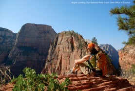
Angels Landing, Zion National Park
Round-Trip: 5.5 miles
Accessible: March to October is best
Level: Strenuous
Angels Landing is a stunning sandstone fin staking its claim on the Zion National Park landscape. Not one for the casual stroller – for views like these you’ll have to part with some hard-earned sweat.
The first few miles take in the Virgin River alongside the West Rim Trail, gently gaining elevation on sandy terrain. Once you pass through Refrigerator Canyon it’s so-long to the river and time to brace yourself for the 21 switchbacks that make up Walter’s Wiggles.
Give this hike a miss if you have a fear of heights – an exposed rock spine features built-in chains to guard against the 1,000-feet drop-off on either side. For the same reason it’s not what you’d call kiddie-safe.
Before you know it you’ll be taking in the 360-vista of some of the world’s best canyons, the Virgin River, and far-off peaks. Remember: the early-bird avoids congestion on the skinny trail.
***
Queens Garden/Navajo Loop Combination Trail, Bryce Canyon
Round-Trip: 3 miles
Accessible: Year-round
Level: Moderate-easy
Hoodoos make for stunning viewing in Utah’s Bryce Canyon, and nowhere are they better showcased than on the Queens Garden/Navajo Loop Combination Trail.
The Queens Garden/Navajo Loop Combination Trail boasts both ground-level and aerial views. Starting at Sunset Point, it descends to the canyon’s base where hoodoos come in spectacular shades of red. From there you’ll head back up through the Wall Street section, dwarfed by sandstone spires, towards the world-famous Thor’s Hammer.
Bryce Canyon’s regular Night Sky programmes mean you can spend the evening eyeballing thousands of stars. When the moon’s in the sky like a big pizza pie, the night hike is on. Sans moon? Head to the visitors’ centre and ogle the evening through the telescopes provided.
***
The Narrows, Zion National Park
Round-Trip: 16 miles top to bottom (Permit Required)
Accessibility: Year-round, although June to September is best
Level: Moderate-strenuous
A trail popular with keen hikers, for 16 miles Zion National Park’s The Narrows winds through Utah’s signature red sandstone canyon, at times spanning 2,000 feet high and just 20 feet wide.
Say goodbye to dry feet for much of The Narrows. Hikers spend a lot of time in the turquoise waters of Virgin River, which may be as high as waist-deep. Meanwhile, opportunistic plants and ponderosa pines grow from the unlikeliest nooks and crannies.
Hike from top to bottom in a single (long) day or tackle just 6 miles out and back from the canyon’s base. If you have two days to spare, consider camping overnight in one of Zion’s 12 designated campsites in the depths of the canyon.
***
Dry Fork Coyote Gulch, Grand Staircase-Escalante National Monument
Round-Trip: 5 miles
Accessibility: March to October
Level: Moderate-easy
Dry Fork is home to some of Utah’s best and most accessible slot canyons, where water and wind has worn down rock to create formations deeper than they are wide.
Peek-a-Boo, Spooky and Brimstone Gulches are just some of the bendy tributaries where hikers can slide, climb and squeeze through cracks and slots. Both Spooky and Peek-a-Boo are child safe, although some adults may need to skip lunch to fit through snug spots. By comparison, Brimstone Gulch is dim and challenging.
If squeezing into slot canyons isn’t your thing, head to Grand Staircase-Escalante National Monument’s Calf Creek Falls instead. There you can take a dip in the swimming hole underneath a waterfall.
***
Rattlesnake Creek Trail, Cedar Breaks National Monument
Round-Trip: 9 miles
Accessibility: March to October
Level: Strenuous
Trekking to the depths of Cedar Breaks isn’t for the faint-hearted. But if you’re fit, adventurous, and willing to put your back into it, the 9-mile Rattlesnake Creek Trail takes in Ashdown Gorge Wilderness Area, a 2,500 feet drop over 4 miles, and Ashdown Creek before reaching Cedar Breaks.
Early indigenous Americans knew Cedar Breaks as the ‘circle of painted cliffs’. The mammoth amphitheatre features arches, columns, spires, fins and pinnacles.
Looking for something a little less sweaty? Two shorter rim hikes are also on offer: Alpine Pond Trail and Spectra Point/Ramparts Overlook Trail.
***
Fisher Towers, Moab
Round-Trip: 5 miles
Accessibility: Year-round
Level: Moderately Easy
The Fisher Towers Trail, east of Utah’s Moab, traverses a maze of bizarre formations including fins, pinnacles, gargoyles, minarets, and spires. The impressive freestanding towers – amongst the tallest in North America – are made of red Cutler sandstone and Moenkopi sandstone, topped off with mud curtains.
Fisher Towers Trail winds its way through the towers throughout the 5-mile round trip. Though easy-going hiking, the lack of shade means a mid-day trek is best avoided.
***
Lake Blanche, Salt Lake City
Round-Trip: 7 miles
Accessibility: May to October
Level: Moderate
If the vistas on offer along the Lake Blanche Trail look familiar, it’s because you’ve stepped into one of the most photographed alpine scenes in all of Utah.
The Sundial Peak spires, in Wasatch Range, were sculpted years ago when glaciers were rife in the upper valleys. In addition to hikers being drawn to the Big Cottonwood Canyon trek, rock climbers and mountaineers also seek out its more challenging routes.
Lake Blanche is a pleasant walk even when things hot up. The hike elevates steadily all the way to the water, and there’s plenty of forest protection from the sun along the trail’s lower half.
In addition to Lake Blanche, Big Cottonwood Canyon is home to Lakes Lillian and Florence. All three are surrounded by breath-taking, glacier-carved rock formations. To reach Florence and Lilian, hike about 200 yards down from the old dam at Lake Blanche’s west end.